Hart Peak - Castle Mountains - California
June 15th, 2017
After close to a 2 year hiatus of climbing any substantial mountains, it was with a slightly heavy heart that we returned to my "second home" in California and headed out to the desert to make a go of Hart Peak in the Castle Mountains National Monument region. Days before the trip, I had learned of my father's passing and with it came a general sorrow that would be my hidden companion on this hike, despite the beauty, company and adventure that would make up the majority of this trek.
The moment we decided to return to California for a family visit, I began my hunt for a suitable mountain in the desert that would be appropriate for my ten year old son and also close to Primm, Nevada where we were staying for a few days. It would be Ocean's first real mountain hike with me, so I searched for something unique looking, but with a short roundtrip distance and great views. I also needed the road to the mountain to be manageable with a low clearance car. It seemed that Hart Peak met all the necessary criteria, so plans were made, GPS routes downloaded and maps installed. Joining us would be Ocean's biological father (Robin) who we met up with in Las Vegas.


After an "energy filled" breakfast at IHOP in Whiskey Pete's, we started our drive out to Hart Peak at around 8am. The one dirt road you need to take (Walking Box Road) is reasonable for a low clearance vehicle, but still take it cautiously in spots. We passed many Joshua trees along the route and had nice views of Castle Mountain in the distance, which really draws the eye in to it's unique shape and structure. No wonder they recently made it a national monument. Very beautiful and I must admit it was calling to me. Maybe one day, but not this day.
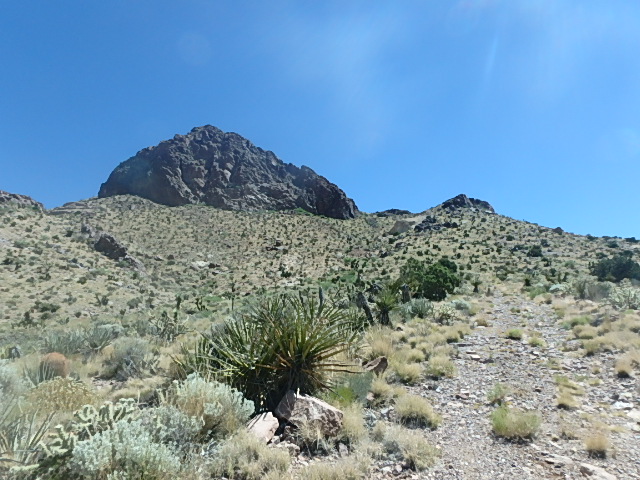
By around 9:30am we reached the "trailhead" and stepped out of our air conditioned car to discover that the weather reports weren't lying. The area was in the midst of a heat wave and it was already hitting over 95°F this early in the morning. We packed up our stores of liquids and promptly headed out in to the desert, following a rough ATV road towards Hart Peak. Route finding is not an issue on this hike starting from where we did. You can pretty much follow this dirt road all the way up to the southern shoulder that connects to the steeper sections of Hart Peak. We did a combination of the road and a wash, which lessens the distance slightly, and were rewarded with many cool rock and mineral discoveries along the way. This is one of the great things about hiking in the California deserts, there is just such an abundance of interesting rocks to find and collect.
As isolated, hot and barren as this place seems (at least to my eyes), there was plenty of plants and wildlife activity along the way. How the bugs, hares, rodents, snakes and lizards survive in these conditions is amazing to me. Animals are one thing though, but humans? How did the native Americans and settlers ever manage to migrate through (or even live in) this harsh, unforgiving wilderness? I just seems unfathomable to live in such a place with so little water available. How was it possible?


Considering it was just a little over two miles to get from our parking spot to the top of Hart Peak, you would think we would have gotten everything done rather quickly, but with Ocean searching for and examining every intersting rock he could find, I had to accept a much slower pace than I'm used to. With the sun climbing higher and beating down ever more brilliantly by the minute, I had to keep reminding him to focus on moving forward as we didn't want to be out there for any length of time in the noon day sun. Nevertheless, the periodic stops to retrieve another "incredible" specimen continued!
By 10:45am we started the gentle uphill climb along the ATV road that heads up towards the southwestern shoulder. Though there is about a 1100 feet of elevation gain for Hart Peak, this portion is a relatively gentle slope along an easy path, which would be fine under most circumstances but with the heat slowly approaching 100°F, this small uptick in exertion stood out much more for us, especially Ocean. Even with a large cowboy hat to give maximum shade to his head, the redness and sweat on his face made it clear that he was really feeling the heat.


Making it to the top edge of the southwestern shoulder, it was now time to head up the slightly steeper northern shoulder that approaches the craggy south face of Hart Peak. Not sure exactly what the temperature was at this point, but clearly Ocean was beginning to suffer from the effects of the heat and was hinting that he might not be able to make it much further. We spotted a rock outcropping near the top of the shoulder and suggested we make it to that point and see if there was any shade. Slowly we made our way up and saw that it was still completely exposed to the sun on all sides of the rock. The shoulder flattened out more at this point and we could see further ahead a small tree (possibly Bristlecone?) that would provide just enough shade for him alone.


Worrying a bit about Ocean getting heat stroke, I was happy to finally reach the little tree and get him out of the sun in the meager shade it provided. We rested at this spot for a little while trying to decide what to do next. Do we head back down or continue up? Both Robin and I were looking longingly at the short distance left to the summit and the exciting scramble it would entail. It was clear that Ocean did not want to go on and so I asked how he would feel about resting under the tree while Robin and I tried to summit. We would be in sight of each other the whole way up (for the most part) and that seemed reasonable to all of us. So we left the filled camel pack of water and food with him, and Robin and I headed towards the final scramble section carrying the bare minimum.
As we made our way around and over boulders, crags, overhangs and cliffs, it felt much more challenging, but also a lot of fun. There were some great views and even some exposure to deal with in one particular spot, but none of it felt unreasonably dangerous and out of our abilities. Just a good class 2 or 3 scramble in the boiling heat.


With the hope to get to the peak as quickly as possible so that we could return to Ocean in a short amount of time, our pace was quickly catching up with me in the incredible heat. We were nearing the final "mound" of the peak, maybe a couple hundred feet left, when I started to feel "funny". All I had to drink was a small amount of Poweraid which was wholly unsatisfactory at quenching my thirst (actually found the excessive sugar a hindrance) and was finding myself feeling woozy and extremely out of breath. I was trying to figure out what was happening. Was it the need for water? Was it the pace? Was it the elevation? Or was it simply the heat? I'd never really felt such a quick onset of symptoms like this on other hikes, so I chalked it up to inexperience in hiking under summer desert conditions.
I took a much needed rest at this point to try and recover a bit. Robin told me he was going to race up to the top to get it done quickly, so I sat there watching him climb as I caught my breath and tried to drink more of the gross Poweraid. I realized how much our body actually signals to us when it wants or doesn't want us to consume something... clearly all it really wanted was simple, fresh, unadulterated water! Oh well, live and learn... and stop falling for BS advertising! Thankfully, taking that short break soon gave me a second wind and I was back on my feet heading up that final section.


I could see Robin sitting at the top and paced myself up the rocks and boulders towards him. Getting within ear shot I called out to him asking if he was on the summit, only to be told that it wasn't the top. This was discouraging as I wanted to return to Ocean as soon as possible, but reaching Robin I could see that the true summit was not far off. Only now it was Robin's turn to try and recover from his quick jaunt up to this point, suggesting that he was satisfied with considering this to be the top.
I was ready to concede the point, but realizing how close we actually were to the true summit, I told him I was going to continue on. It's pretty difficult for me to hold back my peak fever when I'm so close! Not to be outdone, Robin joined me for the last short climb to the peak. Smack dab at noon, with two and half hours of hiking under our belt, we reached the summit of Hart Peak. For some reason there are two geodetic markers on the peak as well as a tin can containing the summit logs, which date back to the 1950's! As Robin noted down our successful summit, we were surprised at how few people have actually climbed this peak.
Oddly, unlike on the way up, there was no breeze at the top and so the heat felt especially intense. Also, there where some flying bugs (ant like creatures) that were swarming around us and having a field day on our exposed skin. As nice as it was to be at the top with those views, I was anxious to get going and return to Ocean and a hopeful breeze.


Heading down was much easier and quick. Robin returned via the ascent route and I decided to head to the left of the craggy area where it was a more gentle slope and easy going. It was along this route that I came across an interesting hole in the cliff side and apparently on the other side Robin came across a bull snake! Within minutes we were safely back with Ocean, where he declared that he was feeling much better and ready to return to the car. It was nice that everything had worked out ok so far, but we knew we needed to get out of this sun as quickly as possible.
So with the intent to find the quickest route back, we decided to head down the western slope instead of the southern ascent shoulder. It wasn't the best decision because any minimization in distance we gained was replaced by an increase in time to manouver through the cactus strewn steep slope. One benefit, however, was that we reached a wonderful shady spot that was indented on the side of the mountain with amazing views. This spot is clearly visible on the ascent and descent because the rock/sandstone wall is bright yellow and quite large. It really stands out and provides some great shade (and probably throughout the day). Its GPS coordinates are 35° 20'25.40"N; 115° 4'48.58"W if you want something more exact, but it's impossible to miss.


Knowing we still had some 2 miles to cover, we left this cozy and comfortable spot and worked our way down the difficult slope for a little ways until we could veer back to the south and reconnect with the ATV trail. Once on the trail, it was just the usual slow and steady walk back to the car trying to follow our ATV/wash combo trail. For the next hour it often felt like a bad western film, with us stuck in the sterotypical desert scene where the characters trod along with an unbearable sun beating down from above. In general, Ocean and I felt ok, but I could tell by Robin's anxiousness to get back that he was starting to have trouble with the heat.


We got off course slightly by following the wash a bit further than we were supposed to, but I had my GPS going with clear directions towards trailhead for the final cross desert "bushwhack". We were only a few hundred meters from the car, but it's always these last few steps that seem to take longest! By 2pm and the heat reaching over 107°F, we finally reached the car with great relief and a sense of accomplishment. My two year hiking dry spell was over!
As we set the AC to full and drove off, it was with a sense of sorrow that I wondered if I would ever be in the California deserts again... a place that has brought me so much joy, adventure, escape, and the all too precious memories of my father and I out there. With so much changing in my family life and the inevitable passing of ones I love, it was entirely possibly that I wouldn't be returning to these regions in the future. And so it stands, an open question, but most likely... goodbye California.
Goodbye dad.
Hike Information
- Round trip distance from parking spot to Hart Peak: Approximately 4.2 miles (6.75 km)
- Hart Peak elevation: 5,610 feet (1,709 m)
- Elevation Gain from parking area to peak: 1,119 feet (341 m)
- GPS Coordinates of Hart Peak: 35° 20'33.80"N; 115° 4'47.16"W (NAD83/WGS84)
Driving directions can be found on Hart Peak's Summit Post page.
Comments (2)
Wonderfully written account of your hiking adventure. I could imagine the heat you described and then the eventual relief of the air conditioned car. I love the pictures you posted, especially the last one. :-) I remember that moment so vividly. Dad had his mouth in an open smile and I remember thinking how cool that looked. So cool in fact, that I mimicked the expression. I miss Dad so much!
I love your hiking accounts. Well written, brings you right along without the discomforts. Many worry some situations though. Glad you make it safely each time.